

The Cotswold Way is the outstanding long-distance hike in the region, running 102 miles between Chipping Campden and Bath through beech woodland and open escarpment. For something shorter, start with the Broadway Tower circular, the Leckhampton loop, the Bourton and Slaughters walks, or the riverside circuit around Coln St Aldwyns and Bibury. All are well waymarked, reachable by rail or bus, and best walked between May and September, or in winter for the clearest views from Cleeve Hill.
TL;DR:
- Most hikers should plan to walk the Cotswold Way from Chipping Campden to Bath to enjoy better views, easier logistics, and transport connections.
- Training for elevation changes is essential, as the trail’s repeated climbs and descents increase the overall difficulty beyond its flat distance.
- Booking accommodations early, especially for peak months, and using luggage transfer services can significantly improve multi-day hiking experiences.
- Shorter walks like the Broadway Tower loop and Leckhampton Hill offer rewarding views and accessible options for casual or limited-time walkers.
- Planning with the Cotswolds App and carrying reliable maps helps avoid navigation issues, especially in remote or offline sections.
Table of Contents
- Top 6 Cotswolds hikes: quick facts and who they’re for
- Cotswold Way: overview, why most walk north to south, and two sample itineraries
- Broadway Tower circular: route card and practical tips
- Bourton, Lower & Upper Slaughters circulars: what to expect
- Leckhampton loop and mobility-accessible options
- Cleeve Hill, Winchcombe and Belas Knap: high-point day walks
- Coln St Aldwyns and Bibury circuits: river valley favourites
- Planning and safety: maps, weather, kit and transport checklist
- How the Cotswolds App helps you plan and execute these hikes
- Local regulations and permissions for walkers
- History and cultural background of key trail sections
- Wildlife and flora to watch for on Cotswolds hikes
- What hiking the escarpment actually teaches you about planning
- Try the Cotswolds App map before your next walk
- Sources
Top 6 Cotswolds hikes: quick facts and who they’re for
Choosing between dozens of Cotswolds walking routes comes down to time, fitness, and what you actually want to see. Here’s a shortlist that covers the region’s best-known ground.
- Cotswold Way – 102 miles, 7 to 10 days, moderate to challenging. Best for anyone wanting the full escarpment experience, from Chipping Campden to Bath.
- Broadway Tower circular – 4 to 4.4 miles, 2 to 3.5 hours, moderate. Best for first-timers who want a big view without a big commitment. Nearest access: Broadway village, or Honeybourne station.
- Leckhampton loop – 4 miles, around 2 hours, easy to moderate, with a mobility-accessible option. Best for families and walkers with limited time. Nearest access: Cheltenham, served by rail.
- Lower and Upper Slaughter with Bourton-on-the-Water – 3 to 6 miles depending on route, 1.5 to 3 hours, easy. Best for gentle riverside walking and photography. Nearest access: Bourton-on-the-Water car parks.
- Cleeve Hill and Winchcombe – 5 to 7 miles, 2.5 to 3.5 hours, moderate. Best for the highest views in the Cotswolds and a detour to Belas Knap. Nearest access: Cheltenham or Winchcombe.
- Coln St Aldwyns and Bibury – 4 to 5 miles, 2 hours, easy. Best for classic Cotswolds scenery without steep climbs. Nearest access: Bibury car park.
Cotswold Way: overview, why most walk north to south, and two sample itineraries
The Cotswold Way runs 102 miles (164 km) from Chipping Campden to Bath, and most walkers finish it in seven to ten days. The high point is Cleeve Hill, at about 330 metres, and the route is waymarked throughout with the National Trails white acorn symbol, offering clear navigation along the trail.
Most people walk it Chipping Campden to Bath rather than the reverse. That’s not just convention. Walking south keeps the escarpment views on your right for most of the trail, matches the orientation used in most guidebooks, and ends in Bath, a city with strong rail and coach connections for the journey home. Finishing in a city with proper transport links rather than a rural village makes the logistics of a multi-day walk considerably less stressful.
Mileage alone understates the effort involved. The trail climbs and descends repeatedly along the escarpment edge, so cumulative ascent across consecutive days makes the walk harder than the flat distance suggests. It is important to train for the climbing, not just the mileage.
Two sample itineraries work well for most fitness levels:
- Relaxed, 10 days: about ten miles a day, allowing time for pub stops, village detours and photography. Good for walkers new to multi-day trails.
- Brisk, 7 days: about fourteen miles a day, suited to fitter, more experienced hikers who want to cover ground quickly.
Book accommodation early, particularly for May and June departures, when demand for Cotswolds guesthouses peaks. Several companies offer luggage transfer between overnight stops, which means you can walk with a light daypack rather than a full pack. Moreton-in-Marsh, Cheltenham and Bath all make useful transport gateways if you want to walk the trail in shorter, separate stages rather than one continuous trip.
Broadway Tower circular: route card and practical tips
This is one of the most rewarding short walks in the northern Cotswolds, and it’s a good introduction to escarpment walking without the multi-day commitment.
- Distance: around 4 to 4.4 miles (6.5–7 km) for the classic village-to-tower loop.
- Grade: moderate, with one steady climb up to the tower and a gentler descent.
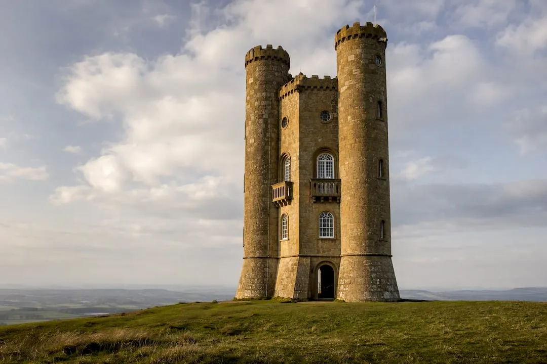
- Highlight: Broadway Tower itself, a striking 18th-century folly with views across several counties on a clear day.
- Village stop: Broadway, with its wide high street, honey-stone cottages, and a good choice of tearooms and pubs.
- Parking: pay-and-display in Broadway village, or a car park near the tower itself for a shorter walk.
- Transport: buses connect Broadway to Moreton-in-Marsh and Evesham; Honeybourne station is the nearest railhead.
Wear proper footwear even for this shorter route. The final approach to the tower is steep and can be slippery after rain, and the open hilltop catches wind that the sheltered village doesn’t hint at.
Bourton, Lower & Upper Slaughters circulars: what to expect
These are the gentlest, most photographed walks in the Cotswolds, and deservedly popular for a reason: honey-stone bridges, clear streams, and almost no climbing.
- Short loop: around 3 miles linking Bourton-on-the-Water with the Slaughters, roughly 1.5 hours.
- Longer loop: extend to 5 to 6 miles by adding a detour towards Naunton or the Warden’s Way, around 3 hours.
- Terrain: mostly flat riverside footpaths, but expect mud along the Windrush after heavy rain, particularly between the two Slaughters.
- Alternative in winter: stick to the field paths above the river rather than the low-lying meadow routes, which flood more readily.
- Parking: several pay car parks in Bourton-on-the-Water; limited roadside parking in the Slaughters, so arrive early in summer.
- Refreshments: plenty of choice in Bourton; the Slaughters have fewer options, so plan your stop before you set off.
Leckhampton loop and mobility-accessible options
Leckhampton Hill sits just south of Cheltenham and offers one of the best short walks for views relative to effort.
- Distance: around 4 miles for the full loop, roughly 2 hours at a steady pace.
- Highlight: Devil’s Chimney, a striking limestone pillar left over from quarrying, visible from the main path.
- Terrain: a mix of grassland and stony track, with one moderate climb to the ridge.
- Accessibility: the Cotswold Way includes a dedicated 2.25-mile mobility scooter route at Leckhampton, with a firmer surface than the main hillside paths.
- Off-road hire: some local providers offer off-road mobility scooter hire for this section, though availability varies.
- Parking: Daisybank Road and Hartley Lane both offer roadside access close to the hill.
Pro Tip: If you’re planning to use the mobility scooter route, contact the local hire provider directly before you travel to confirm surface conditions, since recent weather can change what’s passable.
Cleeve Hill, Winchcombe and Belas Knap: high-point day walks
Cleeve Hill is the highest point on the entire Cotswold Way, and the walk-up from Cheltenham or Winchcombe rewards you with the widest views in the region on a clear day.
- Cleeve Hill loop: around 5 miles, 2.5 to 3 hours, taking in open common land grazed by cattle and skylarks overhead in summer.
- Winchcombe approach: a slightly longer 7 mile option that links the town with the escarpment, popular with walkers based in the valley rather than on the hilltop.
- Belas Knap: a Neolithic long barrow just off the main path, worth the short detour for the false entrance and dry-stone chambers, best explored on a dry day since the approach track can be uneven underfoot.
- Navigation: the open common has fewer landmarks than wooded sections elsewhere on the trail, so a paper map is genuinely useful here, not just a backup.
- Transport: regular buses run between Cheltenham and Winchcombe, making a one-way linear walk practical.
Coln St Aldwyns and Bibury circuits: river valley favourites
Bibury’s row of weavers’ cottages at Arlington Row is one of the most photographed scenes in England, and the walk linking it with Coln St Aldwyns makes the most of the valley setting.
- Distance: 4 to 5 miles, around 2 hours, following the River Coln for much of the route.
- Photo spots: Arlington Row itself, and the trout farm bridge just outside the village.
- Crowds: Bibury gets busy from late morning onwards in summer; an early start or an out-of-season visit gives you the row largely to yourself.
- Parking: a pay car park sits just outside Bibury village centre; Coln St Aldwyns has limited roadside space.
- Transport: no rail link; the nearest useful gateway is Kemble or Cirencester by bus.
Planning and safety: maps, weather, kit and transport checklist
Good planning turns a decent walk into a genuinely enjoyable one, and most of it takes ten minutes before you leave the house.
- Navigation: carry an OS Explorer map alongside your phone, and rely on the National Trails white acorn waymarks to confirm you’re on route. A power bank is worth its weight if you’re navigating by app for a full day.
- Weather: check the Met Office forecast for your start point before setting out, particularly for exposed escarpment sections where wind and visibility change quickly.
- Best months: May to September gives settled walking conditions and the best wildflower displays; winter walking rewards you with the clearest long-distance views across the Severn Vale, though daylight is shorter and paths can be slick.
- Kit: sturdy walking boots, waterproof layers, water, a basic first aid kit, and a way to keep your phone charged.
- Logistics: use Moreton-in-Marsh, Cheltenham or Bath as transport gateways, book accommodation early for May and June, and consider a luggage transfer service for multi-day stages.
- Rights of way: the National Trail guidance on GOV.UK is worth a quick read if you’re planning to stray from the main trail.
Pro Tip: Pair digital navigation with a paper map rather than relying on a single phone. Signal drops out in several of the valley sections, and a dead battery shouldn’t end your day.
How the Cotswolds App helps you plan and execute these hikes
Working out where to park, where to eat, and how to get back to your start point takes as much thought as the walk itself. The Cotswolds App brings that planning into one map.
- Interactive map: filter walks, pubs, parking and accommodation across many listed places.
- Visitor ratings: check which pubs and cafés near your route are worth visiting.
- Camping guides: useful if you’re breaking a multi-day stage into overnight sections rather than day-tripping.
A typical workflow looks like this: pick your stage on the interactive map, locate the nearest car park and a well-rated pub for lunch, then check onward transport back to Bath or Moreton-in-Marsh before you set off.
Local regulations and permissions for walkers
The Cotswold Way and its connecting circular walks run almost entirely along public rights of way, which means you’re legally entitled to walk them on foot without seeking permission. Public footpaths, bridleways and the National Trail itself are protected under long-standing rights of way law, and GOV.UK’s guidance on the Cotswold Way as a National Trail sets out the official route and any local variations you should know before setting off.
Some sections cross farmland, and the usual courtesies apply: keep to the marked path across fields, close gates behind you, and keep dogs on leads where livestock are grazing, particularly around Cleeve Hill and the open common land near Leckhampton. Cattle graze several stretches of the escarpment during summer months, and giving them space rather than walking through a herd is simply good sense.
A handful of sections pass through National Trust or privately managed land, including parts near Broadway Tower and Belas Knap, where access is agreed but not unconditional. Sticking to the waymarked path avoids any ambiguity about where you’re entitled to walk. If you plan to leave the main trail for a detour, checking the route against an OS map first is worth the two minutes it takes, since not every field-edge path connects onward the way it looks like it should.
Nothing about walking these routes requires booking, permits, or advance notice, which is part of why the Cotswolds remains one of the most accessible walking regions in England.
History and cultural background of key trail sections
Chipping Campden, where the Cotswold Way begins, grew wealthy on the medieval wool trade, and its wide high street of honey-coloured stone buildings still reflects that prosperity today. The town’s Market Hall, built in 1627, was paid for by Sir Baptist Hicks — a London silk mercer and money-lender to James I who had bought the manor, rather than a local wool man — and remains one of the most photographed buildings on the entire route.
Broadway Tower has a stranger story. Designed by James Wyatt in 1794 and built in 1798–99 for the 6th Earl of Coventry and his wife Lady Barbara, it settled a question she had asked: whether a beacon lit on the hill would be visible from their home near Worcester, some 22 miles away. It later became a retreat for the designer William Morris, part of the Arts and Crafts movement that drew heavily on Cotswolds craftsmanship and materials.
Belas Knap, encountered on the Cleeve Hill and Winchcombe walks, predates almost everything else on the trail by several thousand years. This Neolithic long barrow is roughly 5,000 years old — English Heritage dates it to around 3000 BC, though some authorities place it several centuries earlier. Its oddest feature is a false entrance at the north end, and opinion differs as to why it is there: it may have been meant to deter robbers, though English Heritage points out that the undisturbed chambers held little worth stealing, and the competing reading is a ritual “spirit door” for the dead. The real burial chambers sit along its sides.
Bath, the trail’s finish, needs little introduction. Its Georgian architecture and Roman baths reflect nearly two thousand years of continuous settlement, and arriving on foot after a week or more of walking gives the city’s grandeur a different weight than arriving by car ever could. The wool wealth that built villages like Chipping Campden and Bibury also financed the churches you’ll pass throughout the route, many with wool merchants’ marks carved into the stonework.
Wildlife and flora to watch for on Cotswolds hikes
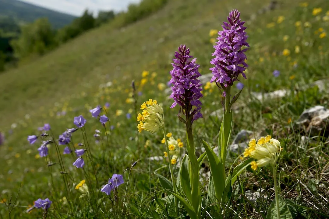
The limestone grassland along the Cotswold Way supports plant life that’s become increasingly rare elsewhere in England. Wildflower meadows around Cleeve Hill and the wider escarpment burst into colour from late spring, with orchids, cowslips and harebells appearing across the unimproved grassland that’s survived here largely because it’s too steep and thin-soiled for intensive farming.
Skylarks are a genuine highlight of the open common sections, particularly around Cleeve Hill and Leckhampton, where their rising song is one of the few sounds breaking the quiet on a still morning. Buzzards circle the escarpment thermals regularly, and you’ll often spot red kites over the wooded valleys near Winchcombe, a species that’s recovered strongly across the region in recent decades.
Beech woodland dominates several stretches of the trail, particularly around Cleeve Hill and towards Painswick further south, and these ancient hangers turn a rich copper in autumn that rivals anything in the New Forest. Roe deer are common in these wooded sections at dawn and dusk, though they tend to vanish into cover the moment they hear boots on gravel.
The rivers along the valley walks, the Coln at Bibury and the Windrush through the Slaughters, support water voles in places and kingfishers that dart along the banks if you’re quiet enough to notice them before they notice you. Bring binoculars if birdwatching interests you at all; the open escarpment sections offer better sightlines than almost anywhere else in the Cotswolds.
What hiking the escarpment actually teaches you about planning
On a staged walk, what undoes a good day is rarely fitness — it’s a flat phone battery or a fully booked B&B in the one village where you actually wanted to stop. Book your overnight stays for popular stretches well ahead of May and June, and carry a way to charge your phone that doesn’t depend on finding a plug socket. Everything else on this list of routes rewards preparation more than stamina.
Try the Cotswolds App map before your next walk
Digital guides are practical alternatives to piecing your route together from scattered blogs and outdated PDFs. Some put thousands of Cotswolds places, walks, pubs, parking spots and accommodation onto a single filterable map, so you can plan a stage of the Cotswold Way or a short circular efficiently.
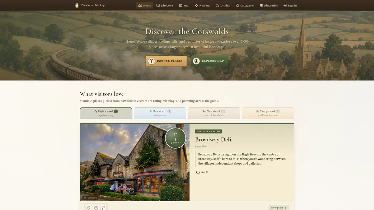
Rather than switching between a route leaflet, a pub review site and a bus timetable, you filter the interactive map by what you actually need that day, whether that’s a dog-friendly pub near Broadway or the nearest car park to Bibury. Visitor ratings help you skip the disappointing options and head straight for the ones locals rate. If you’re extending a walk into an overnight stay, the app’s camping and touring guides cover nearby pitches too.
Open The Cotswolds App and start filtering the map for your next stage, whether that’s Broadway Tower this weekend or the full Cotswold Way next spring.
Sources
- Cotswold Way National Trail | GOV.UK
- Cotswold Way map and information - National Trails
- Met Office weather forecast